Events
Talks, workshops, and other events
Future-Proof Transport Planning: Cities Workshop
Transport planning has always been a complex and multi-disciplinary enterprise requiring wide-ranging skills and methods. Like many fields of research exposed to the data revolution, it is also fast-moving, meaning that it’s hard to know how to keep the work future-proof. This talk will explore the challenges and opportunities of future-proofing transport planning, focusing on the role of data science and open-source software. It will draw on my experience developing and deploying tools such as the Propensity to Cycle Tool for England and Wales (publicly available at www.pct.bike), the Network Planning Tool for Scotland (publicly available at www.npt.scot) and the Biclar tool for Portugal (publicly available at biclar.tmlmobilidade.pt). I will also outline some tools and techniques we have developed at the University of Leeds for working with origin-destination data.
Integrating diverse data sources to support future-proof transport modelling
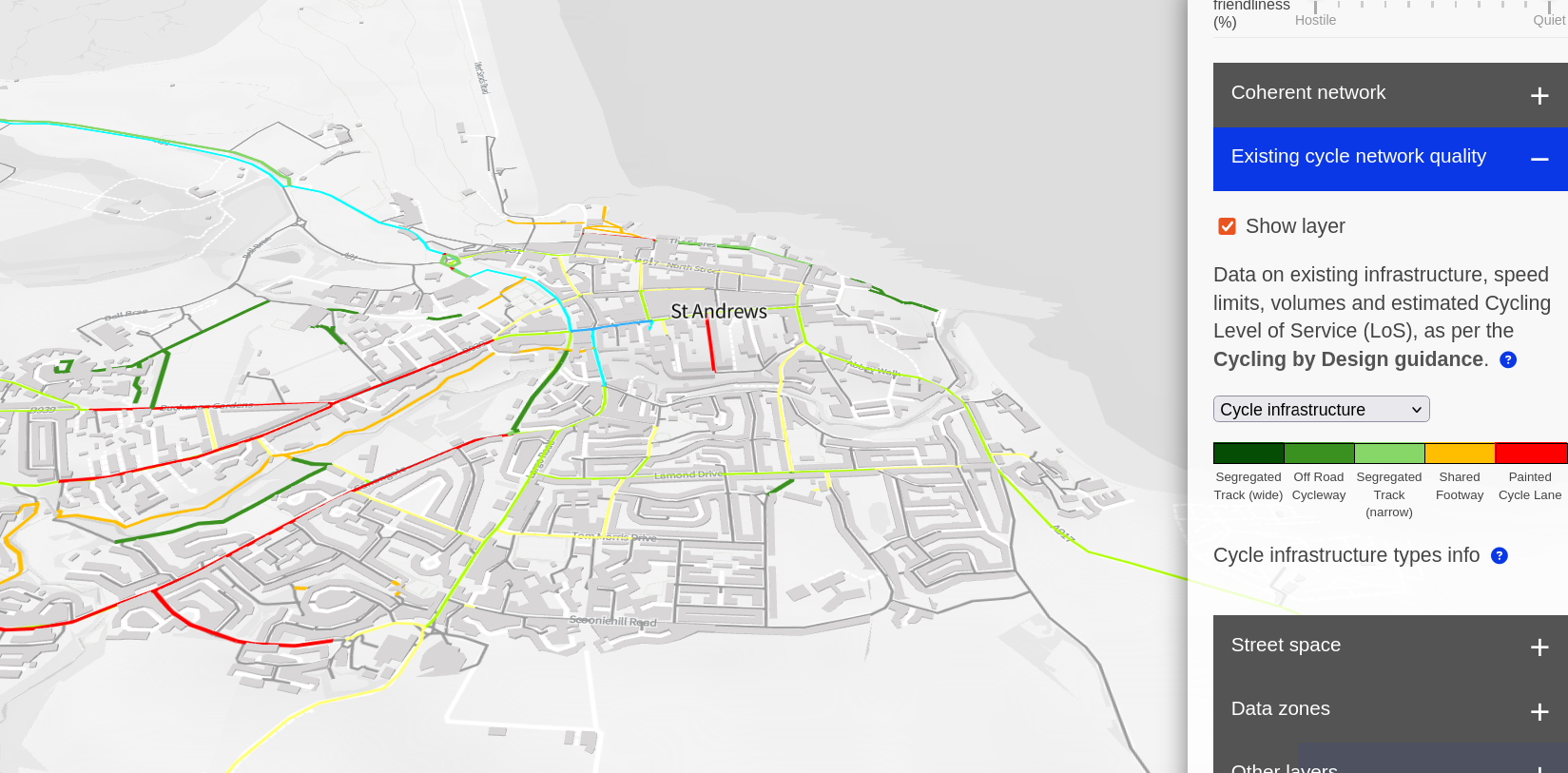
Transport models historically rely on limited input datasets, such as ‘trip generators’ and simplified networks, leading to biases and blind-spots. This lack of data diversity can lead to biases and blind-spots in model outputs. For example, over-reliance on commuting data over-emphasises arterial routes to historic employment centres, while motorised traffic datasets disproportionately highlight long-distance car trips and neglect active travel. Transport models were developed at a time when data was scarce and expensive to collect but the ‘data revolution’ has changed this. We argue that models should be capable of integrating open, proprietary, and crowdsourced, datasets, with ease of integrating new data sources being a key design principle. We present a case study of this approach in the Network Planning Tool for Scotland (NPT), which is publicly available at npt.scot. The NPT integrates data on transport infrastructure from 4 sources: OpenStreetMap, Ordnance Survey (OS) OpenRoads, OS MasterMap Highways, and OS Mastermap Topography, and we are planning to add more, including from the Scottish Spatial Hub, that integrates datasets from Scottish local authorities and partners. Furthermore, the NPT integrates multiple datasets on transport behaviour (including from the Census, the Scottish Household Travel Survey and the British National Travel Survey), and scenarios of change based on international datasets, supporting more data-driven cycling strategies. The results highlight the benefits of data integration, with results tending to improve as more data sources are added, and diminishing returns highlighting the importance of careful selection of input datasets. The approach, based on reproducible code written in open source languages, can be generalised and packaged for benefit of others seeking develop future-proof modelling solutions to transport challenges. We argue that integrating diverse data sources is essential for future-proof transport modelling, enabling adaptation to evolving travel patterns and behaviours.
Seminar in St Andrews: Future-Proof Transport Planning
Transport planning has always been a complex and multi-disciplinary enterprise requiring wide-ranging skills and methods. Like many fields of research exposed to the data revolution, it is also fast-moving, meaning that it’s hard to know how to keep the work future-proof. This talk will explore the challenges and opportunities of future-proofing transport planning, focusing on the role of data science and open source software. It will draw my experience developing and deploying tools such as the Propensity to Cycle Tool for England and Wales (publicly available at www.pct.bike), the Network Planning Tool for Scotland (publicly available at www.npt.scot) and the Biclar tool for Portugal (publicly available at biclar.tmlmobilidade.pt. I will also outline some tools and techniques we have developed at the University of Leeds for working with origin-destination data
Inaugural Lecture: Data Science for Future-Proof Transport Planning
I’m delighted to be giving my Inaugural Lecture at The University of Leeds. I welcome everyone – colleagues, researchers, students, alumni, and visitors – to celebrate this milestone. In this lecture, I’ll discuss my work developing evidence for effective and future-proof transport planning using data science. I’ll cover key methodological, empirical, and applied contributions from my research journey, including: * Developing the national Propensity to Cycle Tool (www.pct.bike) * A secondment to the No. 10 Downing Street data science team * Building data capacity at Active Travel England (plan.activetravelengland.gov.uk) * Current projects on integrated transport in Portugal (biclar.tmlmobilidade.pt) and the Network Planning Tool for Scotland. My approach emphasizes reproducible, open, and verifiable research. I’m passionate about open source software and community building, leading to R packages and books like Geocomputation with R (r.geocompx.org) and Geocomputation with Python (py.geocompx.org). A hands-on ‘Hackathon’ will precede the lecture (details and sign up at itsleeds.github.io/tds). Schedule: * 16:00 – 16:25: Drinks reception (ITS social space) * 16:30 – 17:30: Lecture (Esther Simpson room 1.01) * 17:30 - 18:00: Refreshments (ITS social space)

Tools for Future-Proof Transport Planning: Open Source, Open Access, Reproducible and Collaborative
Transport planning has always been a complex and multi-disciplinary enterprise requiring wide-ranging skills and methods. Proliferating data sources, tools and policy demands – including fast and fair decarbonisation and the need to make active travel the natural choice for everyday trips in cities worldwide – has increased the demands on transport planners and researchers in the field. With burgeoning pressures and options, how to decide what to do? This talk will make the case that reproducible research and open tools are essential ingredients for effective transport planning in the 21st century. It will map out the landscape of open tools for transport planning, distinguish between open source and open access models, and demonstrate how reproducibility is the key not just for research but also for future-proof, socially sustainable and high impact transport planning practice. I will draw on my experience developing, deploying and collaborating on tools such as the Propensity to Cycle Tool for England and Wales (publicly available at www.pct.bike), the Network Planning Tool for Scotland (publicly available at www.npt.scot) and the Biclar tool for Portugal (publicly available at biclar.tmlmobilidade.pt). Each is used to inform strategic transport planning decisions, raising questions around the use of new technologies and collaborations with practitioner and advocacy communities to maximise the long term positive impacts of transport research. The talk will not answer all of these questions but it will surely generate debate and hopefully provide insight into how the field could develop as the data revolution accelerates.
Tools for Future-Proof Transport Planning: Open Source, Open Access, Reproducible and Collaborative
Transport planning has always been a complex and multi-disciplinary enterprise requiring wide-ranging skills and methods. Proliferating data sources, tools and policy demands – including fast and fair decarbonisation and the need to make active travel the natural choice for everyday trips in cities worldwide – has increased the demands on transport planners and researchers in the field. With burgeoning pressures and options, how to decide what to do? This talk will make the case that reproducible research and open tools are essential ingredients for effective transport planning in the 21st century. It will map out the landscape of open tools for transport planning, distinguish between open source and open access models, and demonstrate how reproducibility is the key not just for research but also for future-proof, socially sustainable and high impact transport planning practice. I will draw on my experience developing, deploying and collaborating on tools such as the Propensity to Cycle Tool for England and Wales (publicly available at www.pct.bike), the Network Planning Tool for Scotland (publicly available at www.npt.scot) and the Biclar tool for Portugal (publicly available at biclar.tmlmobilidade.pt. Each is used to inform strategic transport planning decisions, raising questions around the use of new technologies and collaborations with practitioner and advocacy communities to maximise the long term positive impacts of transport research. The talk will not answer all of these questions but it will surely generate debate and hopefully provide insight into how the field could develop as the data revolution accelerates.
CRUSE to safe cycling in Ireland: an open source methodology to support active travel
This talk describes the design, features and potential use of the Cycle Route Uptake and Scenario Estimation (CRUSE) Tool for Ireland, commissioned to support cycle network planning, safety interventions, business cases and project evaluation. The resulting web application is available at https://cruse.bike/, enabling planners, engineers, and other stakeholders to make more evidence-based decisions.
Open Source Tools for Geographic and Transport Research
On Thursday 25th February, we will be hosting our next virtual ReproducibiliTea journal club session. The paper we will be discussing describes the importance of open source tools in research, how to identify open source tools, and types of open source tools that can be used for geographic analysis. We will be joined by the author of the paper, Dr Robin Lovelace, who will be discussing his research into open source tools. Click here for the paper. Please feel free to join even if you have not read the paper, we always have great discussions/ debates on the general concepts in the paper, and would love to hear your views!
Open Access Transport Models
This talk will outline to key concepts and products that will increasingly support evidence based transport planning and cost effective investment of public funds in the 21st Century, open source tools and open access models. Building on two recently published papers on the concepts, in the journal Transport Policy in 2020 and in the Journal of Geographical Systems in 2021, the talk will explore the concepts, demonstrate some evolving new tools and discuss future avenues of research and development. Open tools/models ranged in size from single-purpose tools such as the QGIS plugin AwaP to sophisticated stand-alone multi-modal traffic simulation software such as MATSim, SUMO and Veins. Building on their ability to re-use the most effective components from other open source projects, developers of open source transport planning tools can avoid `reinventing the wheel’ and focus on innovation, the ‘gamified’ A/B Street software, based on OpenStreetMap, a case in point. The talk discusses how to realise the great potential of new approaches to generate the strategic visions of change and evidence that are needed by transport planners in the twenty-first century.